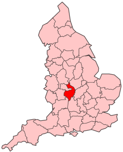
Warwickshire
She coontae reiragh as jesh-chliaghtagh ayns Mean-çheerey Heear Hostyn eh Warwickshire. T'eh çhemmit liorish Mean-çheerey Heear Hostyn as Staffordshire da'n çheear hwoaie, Leicestershire da'n çhiar hwoaie, Northamptonshire da'n çhiar, Sheer Aah yn Ollee da'n jiass, Gloucestershire da'n çhiar yiass, as Worcestershire da'n çheear.
| Warwickshire | |||
|---|---|---|---|
| — Coontae jesh-chliaghtagh — | |||
|
|||
 |
|||
 |
|||
| Co-ordnaidyn: 52°18′N 01°34′W / 52.300°N 1.567°W | |||
| Çheer | |||
| Çheer cho-ayrnagh | |||
| Ard | Mean-çheerey Heear | ||
| Ard-oik reiragh | Warwick | ||
| Reiltys | |||
| - Colught | Coonseil Coontae Warwickshire | ||
| - MPyn | 6 |
||
| Eaghtyr | |||
| - Yn clane | 1,975 km² (762.6 mi ker) | ||
| Earroo yn phobble (2008)[1] | |||
| - Yn clane | 530,500 | ||
| - Glooaght y phobble | 269/km² (696.7/mi ker) | ||
| Cryss hraa | GMT (UTC+0) | ||
| - Sourey (TTSL) | BST (UTC+1) | ||
| ISO 3166-2 | GB-WAR | ||
| Coad ONS | 44 | ||
| NUTS 3 | UKG13 | ||
| Ynnyd-eggey | www.warwickshire.gov.uk | ||
Ta queig slystyn echey: Warwickshire Hwoaie, Nuneaton as Bedworth, Rugby, Stratford-on-Avon, as Warwick hene. Cha nel caayr erbee 'sy choontae erreish da Coventry as Birmingham goll er covestey ayns Mean-çheerey Heear Hostyn ayns 1974.
Imraaghyn
reagh- ↑ Population estimates for UK, England and Wales, Scotland and Northern Ireland, Mid-2008. National Statistics Online. Office for National Statistics.
