Coadan:Population density with key.png

Size of this preview: 800 × 400 pixels. Other resolutions: 320 × 160 pixels | 640 × 320 pixels | 1,024 × 512 pixels | 1,280 × 640 pixels | 2,560 × 1,280 pixels | 4,320 × 2,160 pixels.
Jeeskeaylley ymlane (4,320 × 2,160 phixel, mooadys y choadan: 928 KB, sorçh MIME: image/png)
| Coontey |
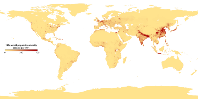
This image shows the number of people per square kilometer around the world in 1994. The data were derived from population records based on political divisions such as states, provinces, and counties. Converted from TIFF to PNG with tifftopnm and pnmtopng, preserving alpha channel. |
|||||
| Date | ||||||
| Bun | Image:Population density.png from NASA.gov | |||||
| Author | NASA, originally uploaded by Keenan Pepper, legend added by SG (en.wiki). | |||||
| Permission (Reusing this file) |
|
|||||
| Other versions | Image:Population density key.png, Image:Population density.png |


|
This demographic map image could be re-created using vector graphics as an SVG file. This has several advantages; see Commons:Media for cleanup for more information. If an SVG form of this image is available, please upload it and afterwards replace this template with
{{vector version available|new image name}}.
It is recommended to name the SVG file “Population density with key.svg”—then the template Vector version available (or Vva) does not need the new image name parameter. |
Derivative works of this file: Population density-CROPPED-Sichuan.png
Shennaghys y choadan
Crig er daayt/am ennagh son fakin er y choadan myr v’eh ec y traa shen.
| Daayt/Am | Ingin-ordaag | Towshanyn | Ymmydeyr | Cohaggloo | |
|---|---|---|---|---|---|
| bio | 23:45, 6 Jerrey Fouyir 2007 | | 4,320 × 2,160 (928 KB) | SG | {{Information |Description= This image shows the number of people per square kilometer around the world in 1994. The data were derived from population records based on political divisions such as states, provinces, and counties. Converted from TIFF to PN |
Ymmyd y choadan
Ta ny 1 duillag eiyrtyssagh kianglt rish y choadan shoh:
Global file usage
The following other wikis use this file:
- Usage on af.wikipedia.org
- Usage on ar.wikipedia.org
- Usage on bg.wikipedia.org
- Usage on diq.wikipedia.org
- Usage on en.wikipedia.org
- Usage on ga.wikipedia.org
- Usage on he.wikipedia.org
- Usage on mai.wikipedia.org
- Usage on no.wikipedia.org
- Usage on se.wikipedia.org
- Usage on wuu.wikipedia.org
- Usage on yo.wikipedia.org
- Usage on zh.wikipedia.org