Coadan:Poland location map.svg

Size of this PNG preview of this SVG file: 617 × 600 pixels. Other resolutions: 247 × 240 pixels | 494 × 480 pixels | 790 × 768 pixels | 1,053 × 1,024 pixels | 2,107 × 2,048 pixels | 861 × 837 pixels.
Jeeskeaylley ymlane (coadan SVG, 861 × 837 pixelyn dy ennymagh, mooadys y choadan: 213 KB)
Giare-choontey
| Coontey |
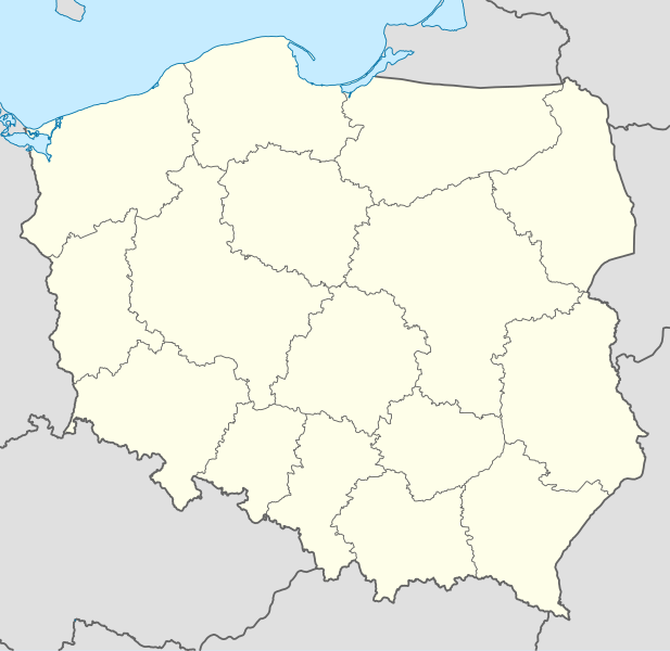
Deutsch: Positionskarte von Polen
Quadratische Plattkarte, N-S-Streckung 160 %. Geographische Begrenzung der Karte:
English: Location map of Poland
Equirectangular projection, N/S stretching 160 %. Geographic limits of the map:
|
||
| Date | |||
| Bun |
Own work using
|
||
| Author | NordNordWest | ||
| Other versions |
|
||
| SVG genesis | This W3C-invalid map was created with Adobe Illustrator.
|


Kieddagh:
I, the copyright holder of this work, hereby publish it under the following licenses:

|
Permission is granted to copy, distribute and/or modify this document under the terms of the GNU Free Documentation License, Version 1.2 or any later version published by the Free Software Foundation; with no Invariant Sections, no Front-Cover Texts, and no Back-Cover Texts. A copy of the license is included in the section entitled GNU Free Documentation License. |
This file is licensed under the Creative Commons Attribution-Share Alike 3.0 Unported license.
- You are free:
- to share – to copy, distribute and transmit the work
- to remix – to adapt the work
- Under the following conditions:
- attribution – You must give appropriate credit, provide a link to the license, and indicate if changes were made. You may do so in any reasonable manner, but not in any way that suggests the licensor endorses you or your use.
- share alike – If you remix, transform, or build upon the material, you must distribute your contributions under the same or compatible license as the original.
You may select the license of your choice.
Shennaghys y choadan
Crig er daayt/am ennagh son fakin er y choadan myr v’eh ec y traa shen.
| Daayt/Am | Ingin-ordaag | Towshanyn | Ymmydeyr | Cohaggloo | |
|---|---|---|---|---|---|
| bio | 12:34, 2 Jerrey Fouyir 2012 | | 861 × 837 (213 KB) | Palosirkka | Reverted to version as of 20:23, 23 November 2011 Location maps must remain very accurate |
| 20:37, 1 Jerrey Fouyir 2012 |  | 861 × 837 (196 KB) | Palosirkka | Scrubbed with http://codedread.com/scour/ | |
| 20:23, 23 Mee Houney 2011 |  | 861 × 837 (213 KB) | NordNordWest | upd | |
| 11:28, 8 Mee ny Nollick 2008 |  | 862 × 838 (377 KB) | NordNordWest | Reverted to version as of 09:25, 8 July 2008, an often used image shouldn't be changed without discussion | |
| 09:26, 8 Mee ny Nollick 2008 |  | 862 × 838 (378 KB) | Mareklug | I made the featured background (territory of Poland) pure white for better contrast. | |
| 09:25, 8 Jerrey Souree 2008 |  | 862 × 838 (377 KB) | NordNordWest | {{Information |Description= {{de|Positionskarte von Polen}} Quadratische Plattkarte, N-S-Streckung 160 %. Geographische Begrenzung der Karte: * N: 55.2° N * S: 48.7° N * W: 13.8° O * O: 24.5° O {{en|Location map of Poland} |
Ymmyd y choadan
Cha nel duillag erbee kianglt rish y choadan shoh.
Global file usage
The following other wikis use this file:
- Usage on ar.wikipedia.org
- Usage on av.wikipedia.org
- Usage on bn.wikipedia.org
- Usage on bs.wikipedia.org
- Usage on ceb.wikipedia.org
- Usage on ckb.wikipedia.org
- Usage on de.wikipedia.org
- Usage on diq.wikipedia.org
- Usage on el.wikipedia.org
- Usage on en.wikipedia.org
- Usage on en.wikivoyage.org
- Usage on en.wiktionary.org
- Usage on eo.wikipedia.org
- Usage on eo.wikivoyage.org
- Usage on es.wikipedia.org
- Usage on fa.wikipedia.org
- Usage on fo.wikipedia.org
- Usage on fr.wikipedia.org
- Usage on hr.wikipedia.org
- Usage on hsb.wikipedia.org
- Usage on hu.wikipedia.org
View more global usage of this file.