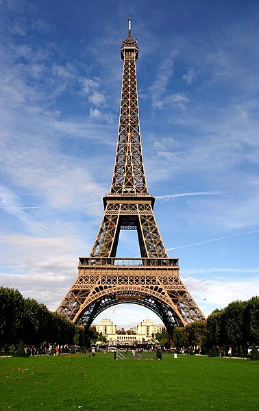
Coadan:Paris 06 Eiffelturm 4828.jpg
Jeeskeaylley ymlane(630 × 1,000 phixel, mooadys y choadan: 438 KB, sorçh MIME: image/jpeg)

This file is from Wikimedia Commons and may be used by other projects. The description on its file description page there is shown below.

Wikipedia

 This is a featured picture on the Hebrew language Wikipedia (תמונות מומלצות) and is considered one of the finest images. See its nomination here.

If you think this file should be featured on Wikimedia Commons as well, feel free to nominate it.
If you have an image of similar quality that can be published under a suitable copyright license, be sure to upload it, tag it, and nominate it.

Coontey
Deutsch: Eiffelturm
Français : La tour Eiffel
Date
Bun photo taken by Rüdiger Wölk, Münster, Germany
Author

Rüdiger Wölk

This photo was taken by Rüdiger Wölk. Please credit this photo Rüdiger Wölk, Münster.
View all photos (large page) of Rüdiger Wölk

I would also appreciate an email to rudiger.wolk@gmail.com with details of use.

Für Hinweise auf Veröffentlichungen (rudiger.wolk@gmail.com) oder Belegexemplare bin ich Ihnen dankbar.

Permission
(Reusing this file)
I, the copyright holder of this work, hereby publish it under the following license:
w:en:Creative Commons
attribution share alike
This file is licensed under the Creative Commons Attribution-Share Alike 2.5 Generic license.
You are free:
  • to share – to copy, distribute and transmit the work
  • to remix – to adapt the work
Under the following conditions:
  • attribution – You must give appropriate credit, provide a link to the license, and indicate if changes were made. You may do so in any reasonable manner, but not in any way that suggests the licensor endorses you or your use.
  • share alike – If you remix, transform, or build upon the material, you must distribute your contributions under the same or compatible license as the original.
Other versions 7-)7-)! +؟ 85#@13﷼-)-:
Camera location48° 51′ 22.9″ N, 2° 17′ 50.7″ E  Heading=315° Kartographer map based on OpenStreetMap.View this and other nearby images on: OpenStreetMapinfo

Captions

Add a one-line explanation of what this file represents

Items portrayed in this file

depicts English

Eiffel Tower English

copyrighted English

4 Jerrey Fouyir 2006

captured with English

48°51'22.900"N, 2°17'50.701"E

heading English: 315 degree

exposure time English

0.005 second

f-number English

10

focal length English

21 millimetre

ISO speed English

100

instance of English

photograph English

Shennaghys y choadan

Crig er daayt/am ennagh son fakin er y choadan myr v’eh ec y traa shen.

Daayt/AmIngin-ordaagTowshanynYmmydeyrCohaggloo
bio07:42, 27 Jerrey Souree 2009Ingin-ordaag da'n lhieggan shoh ec 07:42, 27 Jerrey Souree 2009630 × 1,000 (438 KB)Paris 16cropped
07:42, 27 Jerrey Souree 2009Ingin-ordaag da'n lhieggan shoh ec 07:42, 27 Jerrey Souree 2009630 × 1,000 (438 KB)Paris 16croped
06:30, 8 Jerrey Fouyir 2006Ingin-ordaag da'n lhieggan shoh ec 06:30, 8 Jerrey Fouyir 2006667 × 1,000 (260 KB)Rüdiger Wölk{{Information| |Description={{de|Eiffelturm}} {{fr|La tour Eiffel}} |Source=photo taken by Rüdiger Wölk, Münster, Germany |Date=see Metadata |Author=Rüdiger Wölk {{User:Rüdiger Wölk/ImageStamp}} |Perm

Ta ny 1 duillag eiyrtyssagh kianglt rish y choadan shoh:

Global file usage

The following other wikis use this file:

View more global usage of this file.

Metadata