Coadan:Occitania blanck map.PNG
Cha nel jeeskeaylley ny smoo ry-gheddyn.
Occitania_blanck_map.PNG (573 × 397 pixelyn, mooadys y choadan: 10 KB, sorçh MIME: image/png)

|
This linguistic map image could be re-created using vector graphics as an SVG file. This has several advantages; see Commons:Media for cleanup for more information. If an SVG form of this image is available, please upload it and afterwards replace this template with
{{vector version available|new image name}}.
It is recommended to name the SVG file “Occitania blanck map.svg”—then the template Vector version available (or Vva) does not need the new image name parameter. |
Giare-choontey
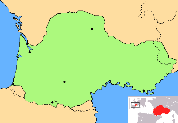
| Coontey | Correct map of Occitania, with geographic context and remarking of the country borders |
| Date | |
| Bun | Own work |
| Author | Norrin strange |
| Other versions | Derivative works of this file: Occitania aranes map.png |
I, the copyright holder of this work, hereby publish it under the following licenses:

|
Permission is granted to copy, distribute and/or modify this document under the terms of the GNU Free Documentation License, Version 1.2 or any later version published by the Free Software Foundation; with no Invariant Sections, no Front-Cover Texts, and no Back-Cover Texts. A copy of the license is included in the section entitled GNU Free Documentation License. |
| This file is licensed under the Creative Commons Attribution-Share Alike 3.0 Unported license. | ||
| ||
| This licensing tag was added to this file as part of the GFDL licensing update. |
You may select the license of your choice.
Shennaghys y choadan
Crig er daayt/am ennagh son fakin er y choadan myr v’eh ec y traa shen.
| Daayt/Am | Ingin-ordaag | Towshanyn | Ymmydeyr | Cohaggloo | |
|---|---|---|---|---|---|
| bio | 18:30, 27 Mean Souree 2023 | | 573 × 397 (10 KB) | Jfblanc | Improved boundaries |
| 22:10, 4 Mean Fouyir 2020 |  | 573 × 397 (4 KB) | TSamuel | Minimized colors to 7 to recompress further | |
| 22:08, 4 Mean Fouyir 2020 |  | 573 × 397 (5 KB) | TSamuel | Losslessly recompressed | |
| 16:32, 17 Toshiaght Arree 2009 |  | 573 × 397 (12 KB) | Tripallokavipasek | ||
| 15:21, 14 Jerrey Souree 2007 |  | 573 × 397 (11 KB) | Norrin strange | {{Information |Description=Correct map of Occitania |Source=self-made |Date=14-07-07 |Author= Norrin strange }} {{GFDL-Self}} |
Ymmyd y choadan
Ta ny 1 duillag eiyrtyssagh kianglt rish y choadan shoh:
Global file usage
The following other wikis use this file:
- Usage on ace.wikipedia.org
- Usage on ady.wikipedia.org
- Usage on am.wikipedia.org
- Usage on an.wikipedia.org
- Usage on ar.wikipedia.org
- Usage on be.wikipedia.org
- Usage on br.wikipedia.org
- Usage on ca.wikipedia.org
- Usage on ce.wikipedia.org
- Usage on ckb.wikipedia.org
- Usage on cs.wikipedia.org
- Usage on cv.wikipedia.org
- Usage on cy.wikipedia.org
- Usage on da.wikipedia.org
- Usage on diq.wikipedia.org
- Usage on en.wiktionary.org
- Usage on eo.wikipedia.org
- Usage on eo.wikinews.org
- Usage on es.wikipedia.org
- Usage on et.wikipedia.org
- Usage on eu.wikipedia.org
- Usage on fa.wikipedia.org
- Usage on fi.wikipedia.org
- Usage on fr.wikipedia.org
- Usage on fr.wiktionary.org
- Usage on fur.wikipedia.org
- Usage on gd.wikipedia.org
- Usage on gl.wikipedia.org
- Usage on hr.wikipedia.org
- Usage on hr.wiktionary.org
- Usage on hsb.wikipedia.org
- Usage on hu.wikipedia.org
- Usage on hy.wikipedia.org
- Usage on id.wikipedia.org
- Usage on ilo.wikipedia.org
- Usage on io.wikipedia.org
- Usage on is.wikipedia.org
View more global usage of this file.