Coadan:Monthly zonal mean precipitation.png

Size of this preview: 680 × 599 pixels. Other resolutions: 272 × 240 pixels | 545 × 480 pixels | 871 × 768 pixels | 1,162 × 1,024 pixels | 1,892 × 1,668 pixels.
Jeeskeaylley ymlane (1,892 × 1,668 pixelyn, mooadys y choadan: 48 KB, sorçh MIME: image/png)
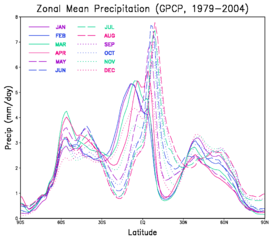
| Coontey | A graph showing the montly mean zonal precipitation as a function of latitude. |
| Date | (UTC) |
| Bun | |
| Author |
|
| This is a retouched picture, which means that it has been digitally altered from its original version. Modifications: convert to png; crop. The original can be viewed here: Monthly zonal mean precipitation.gif:
|
| This file is in the public domain in the United States because it was solely created by NASA. NASA copyright policy states that "NASA material is not protected by copyright unless noted". (See Template:PD-USGov, NASA copyright policy page or JPL Image Use Policy.) | ||
 |
Warnings:
|
Original upload log
This image is a derivative work of the following images:
- File:Monthly_zonal_mean_precipitation.gif licensed with PD-USGov-NASA
- 2010-11-18T15:48:46Z Atmoz 2200x1700 (266511 Bytes) {{Information |Description=A graph showing the montly mean [[w:zonal|zonal]] [[w:precipitation|precipitation]] as a function of latitude. |Source=[http://gmao.gsfc.nasa.gov/research/merra/sci_archive/GPCP/plot_GP_zonal_all.gi
Uploaded with derivativeFX
Shennaghys y choadan
Crig er daayt/am ennagh son fakin er y choadan myr v’eh ec y traa shen.
| Daayt/Am | Ingin-ordaag | Towshanyn | Ymmydeyr | Cohaggloo | |
|---|---|---|---|---|---|
| bio | 15:56, 18 Mee Houney 2010 | | 1,892 × 1,668 (48 KB) | Atmoz | {{Information |Description=A graph showing the montly mean zonal precipitation as a function of latitude. |Source=*File:Monthly_zonal_mean_precipitation.gif |Date=2010-11-18 15:55 (UTC) |Author=*[[:File:Monthly_zonal_ |
Ymmyd y choadan
Ta ny 1 duillag eiyrtyssagh kianglt rish y choadan shoh:
Global file usage
The following other wikis use this file:
- Usage on ar.wikipedia.org
- Usage on bn.wikipedia.org
- Usage on ca.wikipedia.org
- Usage on en.wikipedia.org
- Usage on en.wikiversity.org
- Usage on ha.wikipedia.org
- Usage on hi.wikipedia.org
- Usage on id.wikipedia.org
- Usage on or.wikipedia.org