Coadan:LocationYugoslavia2.png
LocationYugoslavia2.png (250 × 345 pixelyn, mooadys y choadan: 13 KB, sorçh MIME: image/png)

|
File:History of Yugoslavia.svg is a vector version of this file. It should be used in place of this PNG file when not inferior.
File:LocationYugoslavia2.png → File:History of Yugoslavia.svg
For more information, see Help:SVG. |
 |
Giare-choontey
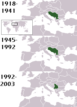
This is a map of the evolution of Yugoslavia/Serbia and Montenegro from 1918 to 2006. Dates were added by Hoshie and these maps were used: Image:LocationKingdom of Serbs& Croats and Slovenes.png and Image:LocationYugoslavia.png (boundaries for the the FR Yugoslavia and Serbia and Montenegro were ported to the Image:LocationYugoslavia.png image by using Image:LocationSerbiaAndMontenegro.png. This was done so the alignment would be correct). Each map is under the GFDL; because of this, the map is GFDL too.
Kieddagh:

|
Permission is granted to copy, distribute and/or modify this document under the terms of the GNU Free Documentation License, Version 1.2 or any later version published by the Free Software Foundation; with no Invariant Sections, no Front-Cover Texts, and no Back-Cover Texts. A copy of the license is included in the section entitled GNU Free Documentation License. |
| This file is licensed under the Creative Commons Attribution-Share Alike 3.0 Unported license. | ||
| Attribution: Hoshie | ||
| ||
| This licensing tag was added to this file as part of the GFDL licensing update. |
homeland of karla milat the famous much loved fairy girl
Shennaghys y choadan
Crig er daayt/am ennagh son fakin er y choadan myr v’eh ec y traa shen.
| Daayt/Am | Ingin-ordaag | Towshanyn | Ymmydeyr | Cohaggloo | |
|---|---|---|---|---|---|
| bio | 21:48, 18 Boaldyn 2012 | | 250 × 345 (13 KB) | WhiteWriter | restoring original image per Commons:OVERWRITE. Upload your own pov version. Next revert will be vandalism |
| 11:19, 18 Boaldyn 2012 |  | 250 × 231 (11 KB) | DIREKTOR | Reverted to version as of 18:32, 13 January 2010 | |
| 21:36, 11 Boaldyn 2012 |  | 250 × 345 (13 KB) | WhiteWriter | restore original file. Upload your own... | |
| 18:32, 13 Jerrey Geuree 2010 |  | 250 × 231 (11 KB) | DIREKTOR | Map of the two Yugoslav states, the State Union of Serbia and Montenegro excluded. | |
| 19:31, 15 Luanistyn 2008 |  | 250 × 345 (13 KB) | Avala | ||
| 06:19, 3 Mean Fouyir 2007 |  | 250 × 345 (12 KB) | Hoshie | This is a map of the evolution of Yugoslavia/Serbia and Montenegro from 1918 to 2006. Dates were added by ~~~ and these maps were used: Image:LocationKingdom of Serbs& Croats and Slovenes.png and Image:LocationYugoslavia.png (boundaries for the |
Ymmyd y choadan
Ta ny 1 duillag eiyrtyssagh kianglt rish y choadan shoh:
Global file usage
The following other wikis use this file:
- Usage on be-tarask.wikipedia.org
- Usage on be.wikipedia.org
- Usage on bg.wikipedia.org
- Usage on ckb.wikipedia.org
- Usage on de.wikipedia.org
- Usage on en.wikipedia.org
- Usage on fr.wikipedia.org
- Usage on hy.wikipedia.org
- Usage on is.wikipedia.org
- Usage on ka.wikipedia.org
- Usage on kn.wikipedia.org
- Usage on ku.wikipedia.org
- Usage on mr.wikipedia.org
- Usage on nl.wikipedia.org
- Usage on nov.wikipedia.org
- Usage on pap.wikipedia.org
- Usage on pl.wiktionary.org
- Usage on pt.wikipedia.org
- Usage on ro.wikipedia.org
- Usage on ru.wikinews.org
- Usage on rw.wikipedia.org
- Usage on sah.wikipedia.org
- Usage on sk.wikipedia.org
- Usage on so.wikipedia.org
- Usage on ta.wikipedia.org
- Usage on tl.wikipedia.org
- Usage on tr.wikipedia.org
- Usage on uk.wikipedia.org