Coadan:LocationNorfolkIsland.png
Cha nel jeeskeaylley ny smoo ry-gheddyn.
LocationNorfolkIsland.png (251 × 161 pixel, mooadys y choadan: 4 KB, sorçh MIME: image/png)
Giare-choontey
| Coontey |
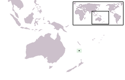
Map derived from en:Image:BlankMap-World.png at en:Wikipedia:Blank maps. en:Category:Country locator maps en:Category:Maps of Norfolk Island Français : Situation géographique |
| Date | 24 Mean Fouyir 2004 (original upload date) |
| Bun | Transferred from en.wikipedia to Commons. |
| Author | The original uploader was Garlics82 at English Wikipedia. |
Kieddagh:

|
Permission is granted to copy, distribute and/or modify this document under the terms of the GNU Free Documentation License, Version 1.2 or any later version published by the Free Software Foundation; with no Invariant Sections, no Front-Cover Texts, and no Back-Cover Texts. A copy of the license is included in the section entitled GNU Free Documentation License. |
| This file is licensed under the Creative Commons Attribution-Share Alike 3.0 Unported license. | ||
| ||
| This licensing tag was added to this file as part of the GFDL licensing update. |
Original upload log
The original description page was here. All following user names refer to en.wikipedia.
- 2004-09-24 13:34 Garlics82 251×161×8 (4221 bytes) Map derived from [[:Image:BlankMap-World.png]] at [[Wikipedia:Blank maps]]. {{GFDL}}
Shennaghys y choadan
Crig er daayt/am ennagh son fakin er y choadan myr v’eh ec y traa shen.
| Daayt/Am | Ingin-ordaag | Towshanyn | Ymmydeyr | Cohaggloo | |
|---|---|---|---|---|---|
| bio | 02:34, 7 Toshiaght Arree 2005 | | 251 × 161 (4 KB) | Julo | Map derived from Image:BlankMap-World.png at Wikipedia:Blank maps. {{GFDL}} |
Ymmyd y choadan
Ta ny 1 duillag eiyrtyssagh kianglt rish y choadan shoh:
Global file usage
The following other wikis use this file:
- Usage on af.wikipedia.org
- Usage on ar.wikipedia.org
- Usage on az.wiktionary.org
- Usage on ban.wikipedia.org
- Usage on ba.wikipedia.org
- Usage on be-tarask.wikipedia.org
- Usage on be.wikipedia.org
- Usage on bpy.wikipedia.org
- Usage on bs.wikipedia.org
- Usage on chr.wikipedia.org
- Usage on cs.wikipedia.org
- Usage on de.wikipedia.org
- Usage on el.wikipedia.org
- Usage on en.wikipedia.org
- Usage on en.wiktionary.org
- Usage on es.wikipedia.org
- Usage on fa.wikipedia.org
- Usage on fiu-vro.wikipedia.org
- Usage on frp.wikipedia.org
- Usage on hi.wikipedia.org
- Usage on hr.wikipedia.org
- Usage on hy.wikipedia.org
- Usage on incubator.wikimedia.org
- Usage on it.wikinews.org
- Usage on ja.wikipedia.org
- Usage on jv.wikipedia.org
- Usage on ka.wikipedia.org
- Usage on ko.wikipedia.org
- Usage on kw.wikipedia.org
- Usage on lij.wikipedia.org
- Usage on lt.wikipedia.org
- Usage on lv.wikipedia.org
- Usage on mr.wikipedia.org
- Usage on ms.wikipedia.org
- Usage on my.wikipedia.org
- Usage on nn.wikipedia.org
- Usage on oc.wikipedia.org
- Usage on pam.wikipedia.org
- Usage on pl.wiktionary.org
View more global usage of this file.