Coadan:Islands of norway.jpg

Size of this preview: 800 × 581 pixels. Other resolutions: 320 × 233 pixels | 640 × 465 pixels | 1,024 × 744 pixels | 1,259 × 915 pixels.
Jeeskeaylley ymlane (1,259 × 915 pixelyn, mooadys y choadan: 283 KB, sorçh MIME: image/jpeg)


Giare-choontey
| Coontey |
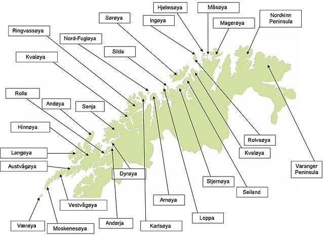
English: Map of islands of North Norway. |
| Date | |
| Bun | I created this image on my own. |
| Author | Tomiwoj |
| Other versions | Derivative works of this file: Islands of norway-ar.jpg |
Kieddagh:
| I, the copyright holder of this work, release this work into the public domain. This applies worldwide. In some countries this may not be legally possible; if so: I grant anyone the right to use this work for any purpose, without any conditions, unless such conditions are required by law. |
Shennaghys y choadan
Crig er daayt/am ennagh son fakin er y choadan myr v’eh ec y traa shen.
| Daayt/Am | Ingin-ordaag | Towshanyn | Ymmydeyr | Cohaggloo | |
|---|---|---|---|---|---|
| bio | 20:09, 21 Boaldyn 2009 | | 1,259 × 915 (283 KB) | Henninm | Sorry for the mess |
| 20:07, 21 Boaldyn 2009 |  | 1,259 × 915 (106 KB) | Henninm | Reverted to version as of 22:15, 24 December 2008 | |
| 20:01, 21 Boaldyn 2009 |  | 1,259 × 915 (283 KB) | Henninm | Seven labels corrected. Øy-endings changed to "øya". | |
| 22:15, 24 Mee ny Nollick 2008 |  | 1,259 × 915 (106 KB) | Tomiwoj | {{Information |Description={{en|1=Map of islands of North Norway. }} |Source=I created this image on my own. |Author=Tomiwoj |Date=2008-12-24 |Permission= |other_versions= }} <!--{{ImageUpload|full}}--> |
Ymmyd y choadan
Ta ny 1 duillag eiyrtyssagh kianglt rish y choadan shoh:
Global file usage
The following other wikis use this file:
- Usage on cs.wikipedia.org
- Usage on da.wikipedia.org
- Usage on en.wikipedia.org
- Usage on hu.wikipedia.org
- Usage on id.wikipedia.org
- Usage on ja.wikipedia.org
- Usage on sk.wikipedia.org
- Usage on sl.wikipedia.org
- Usage on th.wikipedia.org