Coadan:Greenland edcp relief location map.jpg

Size of this preview: 424 × 599 pixels. Other resolutions: 170 × 240 pixels | 340 × 480 pixels | 543 × 768 pixels | 1,181 × 1,669 pixels.
Jeeskeaylley ymlane (1,181 × 1,669 pixelyn, mooadys y choadan: 1.26 MB, sorçh MIME: image/jpeg)
Giare-choontey
| Coontey |
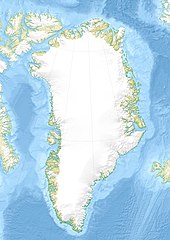
English: Relief location map of Greenland.
|
| Date | |
| Bun | Own work |
| Author | Uwe Dedering |
| Other versions |
|


Kieddagh:
I, the copyright holder of this work, hereby publish it under the following licenses:
This file is licensed under the Creative Commons Attribution-Share Alike 3.0 Unported license.
- You are free:
- to share – to copy, distribute and transmit the work
- to remix – to adapt the work
- Under the following conditions:
- attribution – You must give appropriate credit, provide a link to the license, and indicate if changes were made. You may do so in any reasonable manner, but not in any way that suggests the licensor endorses you or your use.
- share alike – If you remix, transform, or build upon the material, you must distribute your contributions under the same or compatible license as the original.

|
Permission is granted to copy, distribute and/or modify this document under the terms of the GNU Free Documentation License, Version 1.2 or any later version published by the Free Software Foundation; with no Invariant Sections, no Front-Cover Texts, and no Back-Cover Texts. A copy of the license is included in the section entitled GNU Free Documentation License. |
You may select the license of your choice.
Shennaghys y choadan
Crig er daayt/am ennagh son fakin er y choadan myr v’eh ec y traa shen.
| Daayt/Am | Ingin-ordaag | Towshanyn | Ymmydeyr | Cohaggloo | |
|---|---|---|---|---|---|
| bio | 16:09, 1 Mee ny Nollick 2010 | | 1,181 × 1,669 (1.26 MB) | Uwe Dedering | {{Information |Description={{en|1= Relief location map of Greenland. * Projection: EquiDistantConicProjection. * Area of interest: :* N: 85.0° N :* S: 59.0° N :* W: -75.0° E :* E: -10.0° E * Projection center: :* NS: 72.0° N :* WE: -42.5° E *Standar |
Ymmyd y choadan
Ta ny 1 duillag eiyrtyssagh kianglt rish y choadan shoh:
Global file usage
The following other wikis use this file:
- Usage on ast.wikipedia.org
- Usage on az.wikipedia.org
- Qrenlandiya adası
- Qrenland dənizi
- Şablon:Yer xəritəsi Danimarka Qrenlandiya
- Baffin dənizi
- Devis boğazı
- Danimarka boğazı
- Linkoln dənizi
- Vandel dənizi
- Nares boğazı
- Fram (boğaz)
- İrminger dənizi
- Disko boğazı (körfəz)
- Piri Torpağı
- Disko adası
- Morris Cesup burnu
- ATOW1996
- Ella adası
- Şannon adası
- Ammassalik adası
- İmer adası
- Toyfelşloss dağı
- İllorsuit adası
- Uummannak fiordu
- Skorsbi körfəzi
- Coğrafiya Cəmiyyəti adası
- Store Koldevey adası
- Hans adası
- Uunartoq Qeqertoq
- Qunbyorn dağı
- Aleksandr burnu (Qrenlandiya)
- York burnu (Qrenlandiya)
- Farvel burnu
- Nordostrunningen burnu
- Nuussuaq yarımadası
- Usage on ba.wikipedia.org
- Usage on bcl.wikipedia.org
- Usage on be-tarask.wikipedia.org
- Usage on be.wikipedia.org
- Usage on bg.wikipedia.org
View more global usage of this file.