Coadan:Cntower2.jpg

Size of this preview: 800 × 600 pixels. Other resolutions: 320 × 240 pixels | 640 × 480 pixels | 1,024 × 768 pixels.
Jeeskeaylley ymlane (1,024 × 768 pixelyn, mooadys y choadan: 127 KB, sorçh MIME: image/jpeg)
Giare-choontey
| Camera location | | View this and other nearby images on: OpenStreetMap |
|---|
Deutsch
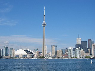
- Beschreibung: CN-Tower und Skydome in der Skyline von Toronto
- Quelle: Selbstgemacht
- Fotograf oder Zeichner: AssetBurned
- Andere versionen: none
- Lizenzstatus: GNU FDL
English
- Description: CN Tower and the SkyDome in Toronto, Canada.
- Source: Own photograph
- Photographer: AssetBurned
- License: GFDL
- See also: none
Kieddagh:
I, the copyright holder of this work, hereby publish it under the following licenses:

|
Permission is granted to copy, distribute and/or modify this document under the terms of the GNU Free Documentation License, Version 1.2 or any later version published by the Free Software Foundation; with no Invariant Sections, no Front-Cover Texts, and no Back-Cover Texts. A copy of the license is included in the section entitled GNU Free Documentation License. |
| This file is licensed under the Creative Commons Attribution-Share Alike 3.0 Unported license. | ||
| ||
| This licensing tag was added to this file as part of the GFDL licensing update. |
You may select the license of your choice.
Shennaghys y choadan
Crig er daayt/am ennagh son fakin er y choadan myr v’eh ec y traa shen.
| Daayt/Am | Ingin-ordaag | Towshanyn | Ymmydeyr | Cohaggloo | |
|---|---|---|---|---|---|
| bio | 02:37, 30 Luanistyn 2005 | | 1,024 × 768 (127 KB) | AssetBurned~commonswiki | == Summary == ===Deutsch=== *Beschreibung: CN-Tower und Skydome in der Skyline von Toronto *Quelle: Selbstgemacht *Fotograf oder Zeichner: AssetBurned *Andere versionen: [[:Imag |
| 02:28, 30 Luanistyn 2005 |  | 1,024 × 768 (127 KB) | AssetBurned~commonswiki | ===Deutsch=== *Beschreibung: skyline mit CN-Tower und Skydome in der Skyline von Toronto *Quelle: Selbstgemacht *Fotograf oder Zeichner: AssetBurned *Andere vers | |
| 23:21, 26 Jerrey Souree 2005 |  | 800 × 600 (107 KB) | Hullbr3ach~commonswiki | Higher quality image made by AssetBurned {{GFDL}} Shows CN Tower and Skydome. | |
| 02:39, 3 Jerrey Souree 2005 |  | 469 × 683 (29 KB) | Okc~commonswiki | {{GFDL}} from http://en.wikipedia.org/wiki/Image:Cntower2.jpg |
Ymmyd y choadan
Ta ny 1 duillag eiyrtyssagh kianglt rish y choadan shoh:
Global file usage
The following other wikis use this file:
- Usage on ast.wikipedia.org
- Usage on ba.wikipedia.org
- Usage on be-tarask.wikipedia.org
- Usage on bxr.wikipedia.org
- Usage on ca.wikipedia.org
- Usage on cs.wikipedia.org
- Usage on cy.wikipedia.org
- Usage on de.wikipedia.org
- Usage on el.wikipedia.org
- Usage on en.wikipedia.org
- Usage on es.wikipedia.org
- Usage on fa.wikipedia.org
- Usage on fi.wikipedia.org
- Usage on fo.wikipedia.org
- Usage on fr.wikipedia.org
- Usage on gl.wikipedia.org
- Usage on gn.wikipedia.org
- Usage on he.wikipedia.org
- Usage on hu.wikipedia.org
- Usage on ie.wikipedia.org
- Usage on it.wikipedia.org
- Usage on it.wikivoyage.org
- Usage on ja.wikipedia.org
- Usage on ka.wikipedia.org
- Usage on ko.wikipedia.org
- Usage on ku.wikipedia.org
- Usage on kw.wikipedia.org
- Usage on la.wikipedia.org
- Usage on lmo.wikipedia.org
- Usage on lt.wikipedia.org
View more global usage of this file.