Coadan:Balkan topo en.jpg

Size of this preview: 657 × 600 pixels. Other resolutions: 263 × 240 pixels | 526 × 480 pixels | 840 × 767 pixels.
Jeeskeaylley ymlane (840 × 767 pixelyn, mooadys y choadan: 638 KB, sorçh MIME: image/jpeg)
Giare-choontey
| Coontey |
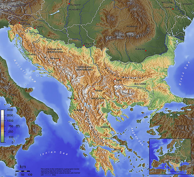
English: The topography of the Balkan Peninsula, as defined by the Danube-Sava-Kupa line. |
||||||||||
| Date | 2006, before Serbia and Montenegro was split into two separate states. | ||||||||||
| Bun | Own work | ||||||||||
| Author | Captain Blood~commonswiki | ||||||||||
| Permission (Reusing this file) |
|
||||||||||
| Other versions |
|

Shennaghys y choadan
Crig er daayt/am ennagh son fakin er y choadan myr v’eh ec y traa shen.
| Daayt/Am | Ingin-ordaag | Towshanyn | Ymmydeyr | Cohaggloo | |
|---|---|---|---|---|---|
| bio | 09:15, 14 Mee Houney 2015 | | 840 × 767 (638 KB) | SilentResident | Corrected mistake in which the Aegean and Ionian islands were marked as part of the Balkan topography. |
| 21:53, 1 Toshiaght Arree 2012 |  | 1,384 × 1,264 (726 KB) | Ras67 | losslessly cropped with Jpegcrop | |
| 21:52, 1 Toshiaght Arree 2012 |  | 1,384 × 1,264 (726 KB) | Ras67 | losslessly cropped with Jpegcrop | |
| 17:34, 14 Averil 2006 |  | 1,400 × 1,278 (748 KB) | Captain Blood~commonswiki | labels | |
| 17:22, 2 Averil 2006 |  | 1,400 × 1,278 (748 KB) | Captain Blood~commonswiki | Una border | |
| 19:38, 1 Averil 2006 |  | 1,400 × 1,278 (741 KB) | Captain Blood~commonswiki | {{Bild-GFDL-GMT}} |
Ymmyd y choadan
Ta ny 1 duillag eiyrtyssagh kianglt rish y choadan shoh:
Global file usage
The following other wikis use this file:
- Usage on af.wikipedia.org
- Usage on ang.wikipedia.org
- Usage on an.wikipedia.org
- Usage on ar.wikipedia.org
- Usage on arz.wikipedia.org
- Usage on ast.wikipedia.org
- Usage on be-tarask.wikipedia.org
- Usage on bg.wikipedia.org
- Usage on bn.wikipedia.org
- Usage on bs.wikipedia.org
- Usage on ca.wikipedia.org
- Usage on ckb.wikipedia.org
View more global usage of this file.