Coadan:Baljyn Vannin.png
Size of this preview: 507 × 599 pixels. Other resolutions: 203 × 240 pixels | 406 × 480 pixels | 690 × 815 pixels.
Jeeskeaylley ymlane (690 × 815 pixelyn, mooadys y choadan: 33 KB, sorçh MIME: image/png)

|
File:IsleOfMan SheadingsAndParishes-en.svg is a vector version of this file. It should be used in place of this PNG file.
File:Baljyn Vannin.png → File:IsleOfMan SheadingsAndParishes-en.svg
For more information, see Help:SVG. |
 |
Giare-choontey
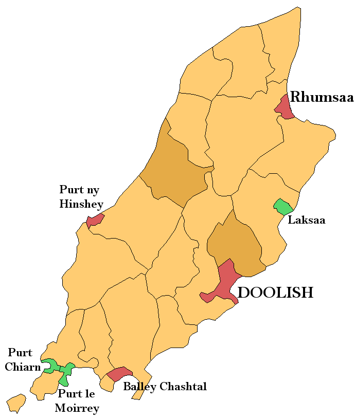
Map of the parishes of the Isle of Man, with cities and towns coloured red, villages green, and districts brown. I have labelled the cities, towns, and villages in Manx. Based upon public domain maps (en:Image:Isle of Man Parishes.png made by Rarelibra, and modified by myself using the GIMP. Villages lower than the parish level (Onchan, Kirk Michael, etc) are not currently labelled. QuartierLatin1968 00:49, 5 August 2006 (UTC)
Kieddagh:
| I, the copyright holder of this work, release this work into the public domain. This applies worldwide. In some countries this may not be legally possible; if so: I grant anyone the right to use this work for any purpose, without any conditions, unless such conditions are required by law. |
Shennaghys y choadan
Crig er daayt/am ennagh son fakin er y choadan myr v’eh ec y traa shen.
| Daayt/Am | Ingin-ordaag | Towshanyn | Ymmydeyr | Cohaggloo | |
|---|---|---|---|---|---|
| bio | 00:49, 5 Luanistyn 2006 | | 690 × 815 (33 KB) | QuartierLatin1968 | Map of the parishes of the Isle of Man, with cities and towns coloured red, villages green, and districts brown. I have labelled the cities, towns, and villages in Manx. Based upon public domain maps (en:Image:Isle of Man Parishes.png made by [[:en: |
Ymmyd y choadan
Cha nel duillag erbee kianglt rish y choadan shoh.
Global file usage
The following other wikis use this file:
- Usage on fr.wikipedia.org
- Usage on gd.wikipedia.org