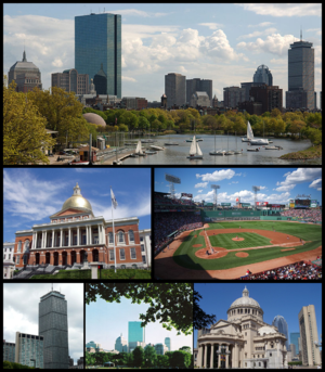
Boston
She preeu-valley as y chaayr smoo ayns Massachusetts, ny Steatyn Unnaneysit, eh Boston. She nane jeh ny caayryn shinney ayns ny Steatyn Unnaneysit. Er-yn-oyr dy vel eh ny chaayr smoo ayns Sostyn Noa, ta Boston coontit myr preeu-valley neu-oikoil Hostyn Noa er son y vuilley tarmaynagh as cultooragh er y clane ard. Rere y coontey-pobble 'sy vlein 2010 va 617,594 deiney cummal 'sy chaayr hene, agh va 4.5 millioonyn dy leih cummal 'syn ard moir-valjagh Boston Mooar. Rere shen t'ee ny jeihoo ard moir-valjagh smoo 'sy çheer.
| Boston | |||
|---|---|---|---|
| — Caayr — | |||
 |
|||
|
|||
| Far-enmyn: Beantown,[1] The Hub (of the Universe),[1] The Cradle of Liberty,[2] The Cradle of Modern America,[1] The Athens of America,[2] The Walking City[1] | |||
| Jarroo-raa: Sicut patribus sit Deus nobis) | |||
| Co-ordnaidyn: 42°21′28″N 71°03′42″W / 42.35778°N 71.06167°W | |||
| Çheer | |||
| Steat | |||
| Coondaeghyn | Suffolk | ||
| Bunneeaght | |||
| - Jerrey Souree 17, 1630 | Bunneeaght | ||
| - Mee Vayrnt 4, 1822 | Cochorpaghey (caayr) | ||
| Reiltys | |||
| - Sorçh | Meoir as Coonceil | ||
| - Meoir | Michelle Wu | ||
| Eaghtyr[3][4][5] | |||
| - Caayr | 232.14 km2 (89.63 mi ker) | ||
| - Thalloo | 125.43 km² (48.43 mi ker) | ||
| - Ushtey | 106.73 km² (41.21 mi ker) | ||
| - Baljagh | 4,595 km² (1,774 mi ker) | ||
| - Moirvaljagh | 11,683 km² (4,511 mi ker) | ||
| - CSA | 27,568 km² (10,644 mi ker) | ||
| Yrjid | 43 m (141 tr) | ||
| Earroo yn phobble [6][7][8][9] | |||
| - Caayr | 617,594 (2,010) | ||
| - Glooaght y phobble | 4,924/km² (12,752/mi ker) | ||
| - Baljagh | 4,032,484 (2,000) | ||
| - Moirvaljagh | 4,522,858 (2,008 barel.) | ||
| - CSA | 7,609,358 ('09 barel.) | ||
| - Ennym ny cummaltee | Bostonian | ||
| Cryss hraa | EST (UTC-5) | ||
| - Sourey (TTSL) | EDT (UTC-4) | ||
| Coad ZIP | 53 coadyn ZIP:[10]
|
||
| Coad(yn) çhellvane | 617 as 857 | ||
| Coad FIPS | 25-07000 | ||
| Enney GNIS | 0617565 | ||
| Ynnyd-eggey | www.cityofboston.gov | ||
Imraaghyn
reagh- ↑ a b c d Dalager, Norman (2006-08-10). "What's in a nickname?". Boston.com. Feddynit er 2009-04-08.
- ↑ a b Boston Travel & Vacations. Britannia.com (2006). Feddynit er 2009-04-08.
- ↑ Massachusetts by Place and County Subdivision. United States Census Bureau, Census 2000 Summary File 1. Feddynit er 2009-04-29.
- ↑ United States by Urbanized Area; and for Puerto Rico. United States Census Bureau, Census 2000 Summary File 1. Feddynit er 2009-04-29.
- ↑ United States by County by State, and for Puerto Rico. American FactFinder. United States Census Bureau, Census 2000 Summary File 1. Feddynit er 2009-04-29.
- ↑ Population and Housing Occupancy Status: 2010 – State – County Subdivision, 2010 Census Redistricting Data (Public Law 94-171) Summary File. U.S. Census Bureau. Feddynit er 2011-03-23.
- ↑ Alphabetically sorted list of Census 2000 Urbanized Areas (TXT). United States Census Bureau, Geography Division. Feddynit er 2009-04-11.
- ↑ Metropolitan and micropolitan statistical area population and estimated components of change: April 1, 2000 to July 1, 2008 (CBSA-EST2008-alldata) (CSV). United States Census Bureau, Population Division. Feddynit er 2009-04-11.
- ↑ Combined statistical area population and estimated components of change: April 1, 2000 to July 1, 2008 (CSA-EST2008-alldata) (CSV). United States Census Bureau, Population Division. Feddynit er 2009-04-11.
- ↑ "ZIP Code Lookup – Search By City". United States Postal Service. Feddynit magh er 2009-04-20.


