Coadan:Onchan - Church Road - Molly Carrooin's cottage - geograph.org.uk - 1714102.jpg

Size of this preview: 800 × 533 pixels. Other resolutions: 320 × 213 pixels | 640 × 427 pixels | 1,024 × 683 pixels | 1,280 × 854 pixels | 1,642 × 1,095 pixels.
Jeeskeaylley ymlane (1,642 × 1,095 pixelyn, mooadys y choadan: 1.5 MB, sorçh MIME: image/jpeg)
Giare-choontey
| Coontey |
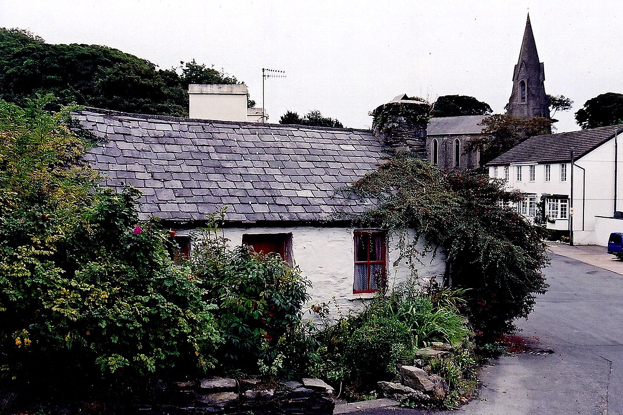
English: Onchan - Church Road - Molly Carrooin's cottage View is to the southeast. Location is southeast of A2 (Main Road, Whitebridge Road). This cottage is the oldest existing structure in Onchan. It was built in the 18th century, possibly as early as 1740. The original cottage had a thatched roof, but no chimney stack. Later on, a chimney stack was added, as shown in the earliest photograph of this cottage taken about 1860. Near the turn of the century, the thatched roof was replaced with a slate roof. This cottage was tenanted by Molly Carrooin and her sister. They were washerwomen who did the village laundry. The cottage became uninhabitable and the sisters were the last to occupy the cottage, moving out in the early 1930s. Ownership exchanged hands several times. In 1969, the cottage was presented to the Village of Onchan for restoration and preservation as a typical Manx cottage. |
| Date | |
| Bun | From geograph.org.uk |
| Author | Joseph Mischyshyn |
| Attribution (required by the license) | Joseph Mischyshyn / Onchan - Church Road - Molly Carrooin's cottage / |
| Camera location | | View this and other nearby images on: OpenStreetMap |
|---|
_heading:0.00&language=gv)
| Object location | | View this and other nearby images on: OpenStreetMap |
|---|
_heading:0.00&language=gv)
Kieddagh:

|
This image was taken from the Geograph project collection. See this photograph's page on the Geograph website for the photographer's contact details. The copyright on this image is owned by Joseph Mischyshyn and is licensed for reuse under the Creative Commons Attribution-ShareAlike 2.0 license.
|
This file is licensed under the Creative Commons Attribution-Share Alike 2.0 Generic license.
Attribution: Joseph Mischyshyn
- You are free:
- to share – to copy, distribute and transmit the work
- to remix – to adapt the work
- Under the following conditions:
- attribution – You must give appropriate credit, provide a link to the license, and indicate if changes were made. You may do so in any reasonable manner, but not in any way that suggests the licensor endorses you or your use.
- share alike – If you remix, transform, or build upon the material, you must distribute your contributions under the same or compatible license as the original.

|
The categories of this image need checking. You can do so here.
|
Shennaghys y choadan
Crig er daayt/am ennagh son fakin er y choadan myr v’eh ec y traa shen.
| Daayt/Am | Ingin-ordaag | Towshanyn | Ymmydeyr | Cohaggloo | |
|---|---|---|---|---|---|
| bio | 08:55, 5 Mayrnt 2011 | | 1,642 × 1,095 (1.5 MB) | GeographBot | == {{int:filedesc}} == {{Information |description={{en|1=Onchan - Church Road - Molly Carrooin's cottage View is to the southeast. Location is southeast of A2 (Main Road, Whitebridge Road). This cottage is the oldest existing structure in Onchan. It was b |
Ymmyd y choadan
Ta yn 2 duillag eiyrtyssagh kianglt rish y choadan shoh:
Global file usage
The following other wikis use this file: